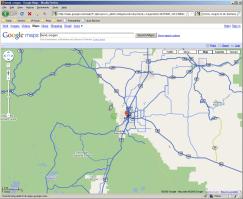
I mentioned nearly a year ago how Central Oregon had a limited bit of coverage. Their coverage was primarily to major highways 97 and 20 through Central Oregon, but it appears that coverage has expanded quite a bit. I don’t know when this exactly changed, but it was sometime within the last few weeks as I use Google maps frequently and had not noticed this.
Central Oregon’s coverage has gotten quite a bit larger than before:
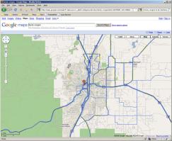
And Bend’s in general has as well:
Now the real fun begins: Can anybody find themselves on there? Or something fun? Or even a rough idea on the date these were done? It does appear that the images this time around not as much snow like the last Street View images, so they must have been taken during a warmer time of the year. I have a feeling they combined images from a couple different times as there’s still snow around Mt. Bachelor but not around Elk Lake. I’m sure there’s a dividing point along there if you “drive” along the highway for a while, as there wouldn’t be snow at Mt. Bachelor without there being snow at Elk Lake.