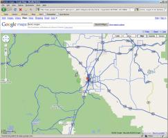
I mentioned nearly a year ago how Central Oregon had a limited bit of coverage. Their coverage was primarily to major highways 97 and 20 through Central Oregon, but it appears that coverage has expanded quite a bit. I don’t know when this exactly changed, but it was sometime within the last few weeks as I use Google maps frequently and had not noticed this.
Central Oregon’s coverage has gotten quite a bit larger than before:
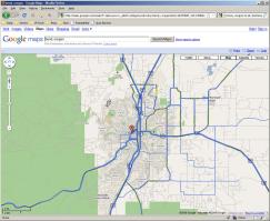
And Bend’s in general has as well:
Now the real fun begins: Can anybody find themselves on there? Or something fun? Or even a rough idea on the date these were done? It does appear that the images this time around not as much snow like the last Street View images, so they must have been taken during a warmer time of the year. I have a feeling they combined images from a couple different times as there’s still snow around Mt. Bachelor but not around Elk Lake. I’m sure there’s a dividing point along there if you “drive” along the highway for a while, as there wouldn’t be snow at Mt. Bachelor without there being snow at Elk Lake.
Comments
Dude, I just wrote up and published this exact same post on Hack Bend… that’s scary! 🙂
I’m thinking they were through town and updated within only the past 2 weeks or so… look at the Tower Theatre sign.
Edited by Jake to include proper hyperlink.
It’s possible in October for snow to be down on the highway at Bachelor but nothing showing at Elk Lake. There is at least a 1300 foot elevation drop. There isn’t any snow at the odot cinder shed either which is at 5500 feet.
Third Street Looks like early October of 2008.
Q-photo’s sign, they closed june 2008, is still up. Denny’s is closed and for sale. Silver Moon hasn’t painted the back half of the brewery yet.
And the Tower Marquee gives it away.
View Larger Map
Jon: Great minds think alike 😉 (I added a proper hyperlink on your URL for ya.)
Anonymous: Thanks for the insight and research.